Courtenay – K’ómoks First Nations Territory
February 5, 2025 By: ROBERT PRITCHARD
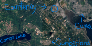
Location: 1252 5th street Courtenay BC
Comox Valley
The east coast of central Vancouver Island is where I currently call home. It rests on K’ómoks First Nations’ (KFN) unceded traditional territory. This territory stretches from today’s Qualicum Beach in the south to a little past Sayward to the north, including many islands throughout the North Salish Sea including Quadra, Cortes, Denman, Hornby and the west coast of Texada (K’ómoks First Nation, n.d.). The KFN and their ancestors are largely responsible for the known history of this land, as they first inhabited these spaces shortly after the retreat of the last ice age as is evidenced by settlements on Quadra Island carbon-dating 9000 years old (Lepofsky et al., 2021), and in the Comox Valley (“Comox” being the anglicised version of the Indigenous word “K’ómoks”) dating over 4000 years.
“Koumox”, as this region was referred by Indigenous Peoples at the time of first contact, means “Land of Plenty” (Cairns, n.d.). The history of the area and its physical geography tend to confirm this. Where I live specifically is five blocks west of downtown Courtenay, which is located at the mouth of the Puntledge River, running into the North Salish Sea’s intertidal region. To the west of my location the terrain elevates through a valley into the Beaufort mountain range, above the Village of Cumberland. A forested valley which travels from the mountains, through many fresh waterways into an ocean bay allows for countless distinct and blending ecosystems in a single region.
“Land of Plenty”
The freshwater bodies are home to cutthroat and rainbow trout and Dolly Varden (Michalski, 2011). Salmon species who are both adaptable to freshwater and marine ecosystems traditionally include chinook, chum, coho, pink, sockeye, and steelhead (Ministry of Environment, n.d.). Marine species range from Orcas, seals, and otters to fish and invertebrates to countless resident and migratory avian species (Turner, 2022).
This region is classified as Coastal Douglas-fir. A Biogeoclamtic Zones map of British Columbia will show that this zone is one of the two rarest of the sixteen classification zones (MacKenzie & Meidinger, 2017). The forest where I live is home to many mammals including black-tailed deer, Roosevelt elk (or ƛ̓uunim in the language of the Nuu-chah-nulth peoples), black bear, cougar, and multiple bat species, among others (O’Malley, 2024; Robinson, n.d.).
Colonization
European colonization in the region began with first contact in 1792 and waves of colonial settlers first arriving in 1862. Local First Nations population of approximately fourteen thousand people pre-contact plummeted to less than two hundred by the end of 1862, largely as a result of two smallpox epidemics eighty years apart. Soon after settlers began arriving forests were cleared, and wetlands were filled to allow for agriculture. A large majority of coastal lands were sold by the British Crown – who asserted ownership of lands without consent of local First Nations in 1846 – for industrialization. The early 20th century saw the son of coal baron Robert Dunsmuir, industrialist and politician James Dunsmuir, purchase mining rights in this area, specifically in what is known today as Cumberland. The decades that followed saw further influxes of settlers, Comox Lake dammed, and all original forest in the region cleared by 1940 in efforts to support the coalmining business.
Results of these events range from dramatically decreased marine and wildlife populations to local Indigenous Peoples lost diversity in cultures and languages. Here are a few specific examples: 1. Sockeye salmon no longer spawn in Comox Lake or its feeder to the ocean, the Puntledge River, since Comox Lake was dammed. 2. Roosevelt elk neared complete extirpation in the early to mid-twentieth century due to over-hunting. Their populations have increased steadily since hunting them was limited by regulations in the 1980s. 3. Traditional Indigenous clam gardens have seen declines in production and species success since industrialization increased local pollution and limited First Nations access to traditional lands (Cairns, n.d.; K’ómoks First Nation, n.d.; Cumberland Museum & Archives, 2020).
Urbanization and Stewardship
The City of Courtenay has experienced an average of 17% population increase per five years since 1981 (Comox Valley, 2016). Due to the steady increase, some previously wooded areas have been cleared to make way for new communities, adding to urban sprawl. However, the Courtenay municipal government has taken steps recently to increase density in the downtown core and nearby surroundings in an effort to reduce urban sprawl and vehicle-use as well as prioritizing “affordable housing” options (City of Courtenay, 2023). Additionally, Courtenay municipal council has directed funding in recent years toward the implementation of bike lanes in many of the city’s main transportation routes and to new garbage, recycling, organic waste bins and waste trucks to empty and transport the materials. According to city officials, the organics waste being redirected from the landfill to the new facility in Campbell River will eliminate approximately 30% of the waste volume from the local landfill in Cumberland (Makinson, 2021).
Reconciliation
It is extremely important to avoid generalizing the innumerable and dynamic cultures of Indigenous Peoples living or once-living on Turtle Island. With this in mind, there is one common theme that can be attributed to the Indigenous tribes, bands and nations that call this land home. It is their understanding with which the success of their people depend upon their natural environments (Beckford, et al., 2010; Lepofsky, et al., 2021; Mohawk, 2013; Modern Treaty Implementation, n.d.). As such, the stewardship of the land that First Nations in BC exhibit should be the standard from which settlers – and settler-established colonial systems – should aim to reach. In Courtenay investments are being made toward representation of the KFN at the Courtenay Museum, the local art gallery and in social programs intended to assist the KFN to build their own self-governing capacity (City of Courtenay, 2023). By supporting and reconciling with the original stewards of this land, the opportunities will hopefully present themselves for increased KFN representation in the overall Courtenay community. This may lead to more learning opportunities by the settler population to realize more sustainable and interconnected lifestyle choices.
Note: The blue circle in my photo is where I live (West Courtenay).
References
Beckford, C. L., Jacobs, C., Williams, N., & Nahdee, R. (2010). Aboriginal Environmental Wisdom, Stewardship, and Sustainability: Lessons From the Walpole Island First Nations, Ontario, Canada. The Journal of Environmental Education, 41(4), 239-248. https://www.tandfonline.com/action/showCitFormats?doi=10.1080%2F00958961003676314.
Cairns, B. (n.d.). History of the Comox Valley. https://comoxmuseum.ca/wp-content/uploads/2021/07/Comox-Valley-BC-History.pdf.
City of Courtenay. (2023). Strategic Priorities 2023-2026. City of Courtenay. https://www.courtenay.ca/assets/City~Hall/Documents/23011_CityOfCourtenay_StrategicPlan_Apr19.pdf.
Comox Valley Regional District. (2016). Census Population of the Comox Valley. BC Stats. https://www.comoxvalleyrd.ca/sites/default/files/docs/About/20170510_chow_census_data_page.pdf.
Cumberland Museum & Archives. (2020). Up the Lake. Cumberland Museum & Archives. https://cumberlandmuseum.ca/up-the-lake/.
K’ómoks First Nation. (n.d.). K’ómoks People History. K’ómoks First Nation. https://komoks.ca/cultures/#history.
Lepofsky, D., Toniello, G., Earnshaw, J., Roberts, C., Wilson, L., Rowell, K., & Holmes, K. (2021). Ancient Anthropogenic Clam Gardens of the Northwest Coast Expand Clam Habitat. Ecosystems 24, 248–260. https://doi-org.ezproxy.tru.ca/10.1007/s10021-020-00515-6.
MacKenzie, W., & Meidinger, D. (2017). The Biogeoclimatic Ecosystem Classification Approach: an ecological framework for vegetation classification. Phytocoenologia. 48. https://www.researchgate.net/figure/Biogeoclimatic-Zone-map-for-British-Columbia-derived-from-vegetation-classification_fig3_321827046.
Makinson, C. (2021). Regional Organics Compost Project Breaks Ground in Cmapbell River. Comox Strathcona Waste Management. https://www.cswm.ca/about/news/regional-organics-compost-project-breaks-ground-campbell-river.
Michalski, T. (2011). Comox Lake Fish and Fisheries Assessment Project Summary, Fisheries Management and Enhancement Plan. Ministry of Forests, Lands and Natural Resource Operations, British Columbia. https://a100.gov.bc.ca/pub/acat/documents/r54694/ComoxLakeProjectFinalReportOctober2011_1537479091425_7477694804.pdf.
Ministry of Environment, Lands and Parks. (n.d.). When & Where to See Salmon. Ministry of Environment, Lands and Parks, British Columbia. https://waves-vagues.dfo-mpo.gc.ca/Library/3185401.pdf.
Modern Treaty Implementation Research Project. (n.d.). Indigenous Relationships to Land. Modern Treaty Implementation Research Project. https://moderntreaties.ca/research-projects-and-results/indigenous-relationships-land.
Mohawk, J. (2013, December 3). Survive and thrive [Video]. YouTube. https://www.youtube.com/watch?v=t6kOA-KtPxw.
O’Malley, N. (2024). Solo hiker saws through parachute to free entangled Vancouver Island elk. Comox Valley Record. https://www.comoxvalleyrecord.com/news/solo-hiker-saws-through-parachute-to-free-entangled-vancouver-island-elk-7648513.
Robinson, H. (n.d.). Comox Valley Forests. Comox Valley Naturalists Society. https://comoxvalleynaturalist.bc.ca/nature-viewing-guide/comox-valley-forests/.
Turner, B. (January 7, 2022). Why is the Salish Sea so rich with life? [Video] YouTube. https://www.youtube.com/watch?v=XT2htr1-MXY&t=525s.