Cau Giay district, Hanoi, Vietnam
June 8, 2025 By:
Location:
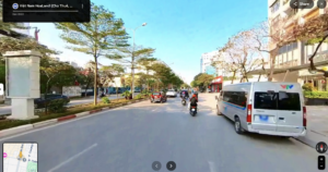
I live in Cầu Giấy district, located to the west of urban Hanoi, the capital city of Vietnam. My neighborhood is a relatively new urban landscape as it historically was a rural agricultural area with some artisanal villages. Since officially becoming a district in 1996, Cau Giay experienced rapid urbanization and is expected to have no farmland left by the late 2020s. (1)
Though Cầu Giấy’s early ecological history isn’t well-documented, understanding Hanoi’s broader landscape evolution helps demonstrates how the changes have shaped my neighborhood.
As part of Red River Delta’s floodplain, Hanoi’s 5000-year history began as a rice farming area before becoming an administrative center in the 7th century. Initially a small trading post near the Citadel, Hanoi’s growth was shaped by imperial conflicts and transformation under French colonialism beginning from the late 1800s, which introduced railways and urban planning. Wars stalled expansion until the 1990s, when the country started adopting Đổi Mới economic reforms that aim at rapid growth. Over the years, boundary expansion has tripled Hanoi’s area, absorbing surrounding farmland, which includes the Cau Giay . (2)
Hanoi’s landscape, wetland, and ecosystem is largely shaped by lakes, ponds, and marshes. As Hanoi grew into a modern capital, these wetlands helped protect the environment by reducing floods, supporting climate adaptation, and preserving cultural heritage. (3)
Like much of Hanoi’s landscape, Cau Giay district is also shaped by its waterway. “Cau Giay” translated to English is “Paper Bridge”, refering to a small bridge crossing over the To Lich river, where papermaking villages were nearby during the monarchal period. This river used to be a distributary of the Red River, which flows from Yunnan in Southwest China through northern Vietnam to the Gulf of Tonkin. Despite its historical significance, the To Lich river is currently very polluted and emits a pungent smell at times. It is one of the most notorious environmental consequences of Hanoi’s urbanization. (4)
Before Cầu Giấy district was urbanized, it was mostly farmlands with lakes and small artisanal villages. These villages in one form or another has existed for many centuries. By the late 20th century, the wooden and straw houses in the villages gradually transformed into modern tube houses. As more houses were built close together, the former dirt path turned into a network of concrete alleyways. (5)
Most families had a small plot of farmland before urbanization changed the landscape. As Hanoi is historically known for its rice cultivation, Vong village of Cau Giay became renowned for its green sticky rice, the ingredient of many Hanoi specialties. The village’s signature crop owes its origin to an ancient tale: many centuries ago, when the rice was about to be harvested, a natural disaster flooded the entire field. To avoid starvation, the Vong villagers cut the young rice grains and roasted them for better preservation. (6)
Rapid urbanization and gentrification, starting from the establishment of the Cau Giay district in 1996, threatened artisanal crafts of historical villages. This meant that rice now needs to be sourced from surrounding provinces instead of farmers growing it themselves. This makes green sticky rice cultivation less profitable than other urban occupations, leaving many to stop practicing the craft. (7)
Cầu Giấy is replacing many acres of residential land with new public infrastructures and residential areas. However, inconsistent development plans has led to confusion, in some cases forced eviction and legal disputes. Due to prolonged legal disputes, some of these newly built residential areas remain vacant, while undeveloped greenfield lands remained abandoned for years. Near my home, an apartment building stands completed but has been unoccupied since I moved here in 2023.
Like much of Hanoi, Cầu Giấy is lacking greenspaces. There are two major parks serving the whole district: Cầu Giấy park and Nghĩa Đô park, which are not in good conditions, both are degraded, with cracked pathways, benches, and playgrounds. I often take evening walks in Cầu Giấy Park and have noticedinadequate lighting, making the area feel unsafe after dark. Yet the park retains some ecological value – its lake supports aquatic life where local people go fishing there, offering a rare connection to nature in the urban environment. Parts of the park are currently under reconstruction, restricting access and further limiting public space. However, there is a sign of progress. A long-abandoned site to the west of Cầu Giấy has recently been transformed into a new park, now open to the public as part of Hanoi’s Children’s Palace.
Sources (some of the sources are in Vietnamese):
(1) Cau Giay District wikipedia page
(4) https://www.vietnamplus.vn/quan-cau-giay-be-day-lich-su-truong-ton-cung-kinh-thanh-thang-long-post888360.vnp
(5) https://ltlskt-dhxd.com/2013/12/16/qua-trinh-bien-doi-kien-truc-nha-o-thi-dan-ha-noi-thoi-phap-thuoc/
(6) https://hanoitimes.vn/a-look-at-banh-com-hanois-favorite-treat-315414.html
(7) https://kinhtedothi.vn/lanh-dao-quan-cau-giay-xin-loi-nguoi-dan-bi-thu-hoi-giay-phep-xay-dung.html