Exercise #1 Local Environmental History
February 21, 2023 By: Nahian Adiba
Location: Khilgaon, Dhaka, Bangladesh

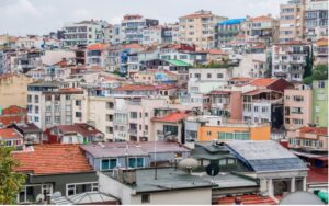
I live in Khilgaon, Dhaka, Bangladesh, a small area in the capital. However, for this assignment, I will describe the local environmental history of the whole city.
The capital and the largest city of Bangladesh is Dhaka. It was formerly known as Dacca. It is the busiest and most populated city in this country. It is the ninth-largest and seventh-most densely populated city in the world, with 8.9 million residents as of 2011 and over 21.7 million residents in the Greater Dhaka Area (1). It is called the city of dreams by the local people in Bangladesh. Before beginning this task, I explored various publications, magazines, and websites to learn more about the history of Dhaka. Even though it is a small and overcrowded city in a small country, Dhaka has a rich history. The environment always has a significant amount of impact on Dhaka’s challenges and development. Recently, Dhaka’s environmental challenges have sparked heated public disputes. However, there has been some appreciation of contemporary environmental issues from a historical perspective; there has been no long-term historical trajectory in such debates. Dhaka’s history spans back to the seventh century A.D. and continues. From its beginnings as a tiny city with few inhabitants to the enormously enlarged demographic and topographic structure, the city has undergone a remarkable historical transformation. (2)
It states that during the Mughal period, particularly under the reign of Shaista Khan (1663–79), Dhaka was one of the world’s greatest cities. Although everyone assumed Dhaka prospered primarily along the bank of the river Buriganga until 1905, evidence suggests that it stretched up to the rivers Tongi or Turag during the Mughal period. There is little discussion of the internal environmental dynamics of those times. Buriganga, the river, and other waterways and canals have been conserved and retained as trade and commuter routes. Thomas Bowery’s late-seventeenth-century tales of Dhaka’s surroundings contain insights that seem fascinating now. The “only problem,” according to the text, was that the sea was closer to the city and had brackish water. Bowrey wrote, citing French scholar and explorer Thevenat, that “the tide rises as far as Dacca, so that the galleys built there may easily trade in the Gulf of Bengala, the Dutch making the most use of it for their commerce…” The second key point mentioned by Bowrey was the river’s vicinity, perhaps the Buriganga, which ran “nearby the wall thereof” and was, in his words, a “great convenience,” its water being “exceptional excellent” and relieving the brackishness of the city water table. Another function of the river, which was 40 miles long, was that it was very navigable and capable of supporting ships weighing 500–600 tonnes. (3)
When comparing the past to the present, there is definite evidence that the water level has decreased, and the mean temperature has increased dramatically. The water level has recently dropped to 140–160 feet, and the current mean temperature looks to be 89 degrees Fahrenheit (31.7 degrees Celsius). Undoubtedly, decreasing rivers and wetlands in and around Dhaka contributes to the city’s rising temperatures. However, as the railroad expanded, the water system’s importance as an economic nerve center decreased. The focus changed away from the river Buriganga, internal smaller streams and canals that served as tributaries to the river Buriganga and other adjacent waterways impacted by the northward growth. “The railway built along the city’s outskirts at the time brought about a significant transformation in the 1880s. As a result, the city shifted its focus to the land, and the river’s banks started to lose economic and social significance.” The British reportedly had environmental settings surrounding their structures at the turn of the century. To the south were built the government offices, while to the north was built a “very vast” garden neighborhood with white homes for public employees. Dhaka predated Delhi in the early twentieth century. This trend continued even during the Pakistani period. The city center near the river was “left to slip into a condition of disrepair” after 1947, when Dhaka saw the revolution of industrial suburbs, particularly at Tejgaon. The project of Ayub Nagar, or the second capital (Sher-e-Bangla Nagar, which today serves as the city’s administrative nerve center), featured the construction of Louis Kahn’s famous parliament building and came at a high cost in terms of wetland. Instead of integration, these were examples of creative modernism in nature depiction. Dhaka’s environmental condition, with many other urban infrastructures, deteriorated following independence.
There was a significant chance of natural disasters, even though environmental changes in Dhaka have generally been for the worse, particularly in the early nineteenth century, due to human factors. There were a lot of earthquakes in 1775 and 1812. The earthquakes of 1872, which occurred on April 10th and 11th, destroyed many houses and public structures in the city and the then-outskirts of Tejgaon. In 1888, a brutal tornado damaged sections of the Nawab family’s palace, including members of the Nawab family, during the storm’s nightfall. The city discovered more than hundreds of bodies, but many more were presumed dead. Over 1,200 people were injured.
If we take the starting point of Dhaka as 1840, Dhaka had expanded immensely in population since then, when it had a population of roughly 70,000. If any massive natural disaster happens in Dhaka, everyone assumes that the whole city will demolish immediately, as it is heavily congested and overpopulated.
Works Cited
https://en.wikipedia.org/wiki/Dhaka
https://www.educarnival.com/degraded-ecological-environment-of-dhaka-city-and-its-management/
https://archive.dhakatribune.com/uncategorized/2016/03/11/in-the-times-of-thomas-bowrey