Juniper Ridge Environmental History
February 23, 2026 By: Clay Roper-Daniels
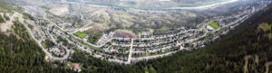
Location: Juniper Ridge
Dr. Norman Fennema
HIST 3991: Environmental History
Clay Roper-Daniels
Feb. 22, 2026
Exercise #1: Local Environmental History
Juniper Ridge Environmental History
I live in Juniper Ridge, a hillside community overlooking the South Thompson River in Kamloops, British Columbia. It is located within the traditional and unceded territory of the Secwépemc Nation. Furthermore, the Secwépemc people lived in the region of Kamloops thousands of years prior to European settlement. From the City of Kamloops website, it explains that Secwépemc communities lived in pit house villages during the winter season. Afterwards, during the warmer months, they would move throughout the territory to hunt and gather while taking advantage of different local environments. For example, the grassland and river valleys would have been home to deer, small game, and various plants. In the meantime, the Thompson River would have provided salmon and other fish. Because the Secwépemc people were mobile with the seasons, rather than stationary, the ecosystem within the area was naturally shaped by their presence. However, in 1811, the arrival of European traders brought significant environmental changes. Firstly, fur trading posts were established along the Thompson Rivers. Later, in 1862, the land was further disrupted by colonial settlement and a surge of gold prospectors. Subsequently, they brought forth a smallpox epidemic that devastated Secwépemc communities. As a result, settlers overtook the control of the region by expanding into farm and ranches
According to the Kamloops Wikipedia, the city quickly experienced rapid growth and development after the completion of the Canadian Pacific Railway in 1885. This allowed for Kamloops to be a major transportation hub and encouraged settlement and resource extraction. Correspondingly, the city was founded in 1893 with a total population off 500 and continued to grow with economic opportunities. Over time, Kamloops expanded outward into the surrounding hills and grasslands, including the area that would later become to be Juniper Ridge. The Wikipedia page on Juniper Ridge states that prior to the construction of the neighborhood, it was a part of the Cordonier Ranch that had 1050 acres. It was primarily used for grazing sheep that inhabited the region each spring. Therefore, the land consisted of agricultural resource extraction before urban development. In the 1970’s, the land was then sold and development of residential subdivision of the Juniper Lands Project began. This transformed the open grassland hillside into a suburban neighbourhood, filled with roads, sewer systems, and housing. It holds as another reminder of the continued expansion of Kamloops and the transformation of its environment from natural to urban.
In particular, the Juniper Ridge West Plan document by Tercon Services goes further in depth on the history of its development. The report claims the surrounding land that sits above the South Thompson River was difficult to develop due to its steep slopes, glacial soils, and dry gullies. For this reason, the converted residential land was shaped by the natural features of the terrain. As a result, some areas were left as open spaces because they were unsuitable for building. These areas included grasslands filled with vegetation, as well as forests containing ponderosa pin and Douglas fir trees. However, many of the ponderosa pine trees died off because of an outbreak of mountain pine beetles, which posed concerns of wildfire risk. Another concern that The Juniper Ridge West Plan emphasized is over the safety of wildlife such as deer, coyotes, and bears. Thus, planning was made to allow for more open spaces so that animals could use it as travel corridors. This demonstrates that Juniper Ridge was more than just a suburban community but highlighted the importance of maintaining it as an active ecological site.
The conservation of Juniper Ridge’s natural ecosystem was taken a step further when a BC Parks Foundation article announced that major funds were contributed to a community crowdfunding campaign to protect the area. In 2025, residents and organizations campaigned together to protect 209 hectares of grasslands. The article further detailed that the land was solely purchased for the preservation of the local ecosystem and to stop further development of the community. Specifically, they are working toward protecting many grassland species at risk and that are rare to British Columbia. Moreover, the conservation of biodiversity in the area is to also protect against the unpredictability of climate change. This act of environmental stewardship highlights the impact local communities can have without having to primarily rely on governments. For the future development of Juniper Ridger, I can only hope they continue efforts on sustainability and conservation, rather than urban expansion.
These sources have show how Juniper Ridge has shaped over time. From early Indigenous hunting and gathering of the Secwépemc people, to the establishment of the Cordonier Ranch, and now to a modern urban neighborhood. Nevertheless, even though there have been significant changes over the course of history, the grassland ecosystem has always been a major environmental feature to protect during every stage. Now, that the landscape has been intertwined with roads and residential buildings, an important balance between people and nature exists.
References
City of Kamloops. “Secwépemc Territory and Heritage.” Accessed February 22, 2026. https://www.kamloops.ca/our-community/indigenous-relations/history.
Wikipedia. “Kamloops.” Last modified 2026. https://en.wikipedia.org/wiki/Kamloops.
Wikipedia. “Juniper Ridge, Kamloops.” Last modified 2026. https://en.wikipedia.org/wiki/Juniper_Ridge,_Kamloops.
Tercon Services. Juniper Ridge West Development Plan. British Columbia, n.d.
BC Parks Foundation. “Grasslands and Conservation.” Accessed February 22, 2026. https://bcparksfoundation.ca