Sault Ste. Marie, Ontario, Canada
December 28, 2025 By: Emily Tithecott
Location: 95 Mark Street, Sault Ste. Marie, Ontario, Canada
Exercise #1: Local Environmental History
Ecological History of Sault Ste. Marie
I live at 95 Mark Street in Sault Ste. Marie, Ontario, in a quiet residential part of the city’s west end. At first glance, the neighbourhood feels unremarkable. It is made up of detached houses, mature trees, paved streets, and small gardens. It is the kind of place people move through daily without giving much thought to how it came to look this way. However, when I began to look at this area through an environmental history lens, it became clear that even this ordinary suburban space reflects long-term ecological change shaped by Indigenous land use, industrial development, and urban expansion.
Before European contact, this area was part of the traditional territory of the Anishinaabe, specifically the Ojibwe people. The land falls within the territory covered by the Robinson–Huron Treaty of 1850, an agreement between the Crown and several Ojibwe bands, including what is now Batchewana First Nation. The treaty was signed during a period of increasing pressure from mining interests and settler expansion. While it opened the land to colonial settlement and resource extraction, it also affirmed Indigenous hunting and fishing rights across the territory, rights that continue to be asserted today (Government of Canada, n.d.; Batchewana First Nation, n.d.).
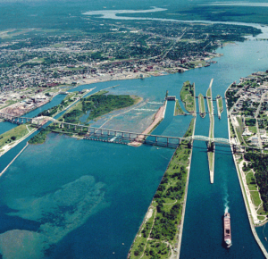
Long before the treaty period, the St. Marys River was central to Anishinaabe life. Located only a short distance from Mark Street, the river functioned as a major transportation corridor and a productive fishing area connecting Lake Superior and Lake Huron. Species such as lake trout, whitefish, sturgeon, and walleye supported local food systems and trade networks. Land use followed seasonal patterns, with fishing, hunting, and gathering activities organised in ways that allowed ecosystems time to recover and regenerate.
Ecologically, the Mark Street neighbourhood sits within the Great Lakes–St. Lawrence forest region. Prior to settlement, the land would have been covered by mixed forest dominated by sugar maple, yellow birch, white pine, and hemlock. Wetlands and small creeks drained toward the St. Marys River, supporting amphibians, birds, and mammals. Wildlife in the region historically included moose, woodland caribou, wolves, black bears, beavers, and a wide range of bird species. These ecosystems were shaped by natural disturbances such as fire and seasonal flooding, which maintained biodiversity and soil health.
During the nineteenth century, European settlement expanded rapidly following the signing of the Robinson–Huron Treaty and the construction of colonial infrastructure. Sault Ste. Marie’s geographic location made it a natural centre for transportation, hydroelectric development, and industry. Logging became a major driver of environmental change, as large areas of forest were cleared to supply sawmills and support economic growth. Railways and roads cut through previously continuous forest, fragmenting habitats and altering natural drainage patterns. Although the area that later became Mark Street was not itself an industrial site, it developed as part of a city built on resource extraction and environmental transformation (Canadian Encyclopedia, n.d.).
Industrial activity intensified in the early twentieth century, particularly with the expansion of steel production. Algoma Steel played a defining role in shaping both the economy and the environment of Sault Ste. Marie. Industrial pollution affected air quality, soil, and water systems, especially in and around the St. Marys River. Even residential neighbourhoods like Mark Street, which were physically separated from heavy industry, were still part of the same environmental system. Shared air, water, and municipal infrastructure meant that industrial impacts extended across the city.
The twentieth century also saw the introduction and spread of invasive species that continue to shape local ecosystems today. Aquatic invasive species such as sea lamprey entered the Great Lakes through shipping routes and canals, contributing to the decline of native fish populations. On land, invasive plants like buckthorn became established in disturbed areas, including urban edges, parks, and nearby forests. These species often outcompete native vegetation and reduce biodiversity, altering the structure and function of local ecosystems (Invasive Species Centre, n.d.).
After the Second World War, suburban development expanded across Sault Ste. Marie. The neighbourhood around Mark Street was built during this period, reflecting planning trends that favoured cars, single-family housing, and paved infrastructure. Forests and wetlands were replaced with lawns, roads, and driveways. Stormwater systems were designed to move water away quickly rather than allowing it to soak into the ground. This increased surface runoff into the St. Marys River and reduced the natural filtration once provided by soils and vegetation.
In more recent decades, there has been increased attention to environmental stewardship at both the municipal and community level. The City of Sault Ste. Marie manages stormwater through retention systems and infrastructure upgrades aimed at reducing flooding and limiting pollution entering local waterways (City of Sault Ste. Marie, n.d.). Composting and recycling programmes help reduce waste, while tree planting initiatives and the protection of nearby natural areas such as the Hiawatha Highlands support biodiversity and provide accessible green space.
Today, wildlife continues to coexist with people in the Mark Street area. White-tailed deer, foxes, raccoons, and many bird species are commonly seen, demonstrating how some animals adapt to urban environments. At the same time, the absence of larger predators and the continued presence of invasive species highlight the lasting ecological impacts of settlement and development.
Looking at my neighbourhood through an environmental history lens has changed how I see it. Mark Street is not simply a residential space but the result of layered environmental decisions, from Anishinaabe land stewardship through the Robinson–Huron Treaty period to industrial growth and suburban expansion. Understanding this history makes it clear that even everyday neighbourhoods are closely connected to broader ecological systems and long-term questions of land use, responsibility, and care.
References
Batchewana First Nation. (n.d.). History and culture. https://batchewana.ca
Canadian Encyclopedia. (n.d.). Sault Ste. Marie. https://www.thecanadianencyclopedia.ca
City of Sault Ste. Marie. (n.d.). Stormwater management. https://saultstemarie.ca
Government of Canada. (n.d.). Robinson–Huron Treaty of 1850. https://www.rcaanc-cirnac.gc.ca
Invasive Species Centre. (n.d.). Invasive species in Ontario. https://www.invasivespeciescentre.ca
Ontario Ministry of Natural Resources and Forestry. (n.d.). Forest management in Ontario. https://www.ontario.ca/page/forest-management