Angus, Ontario
November 14, 2026 By: Richard Wright
Location: 141 King St, Angus, ON L0M 1B0, Canada
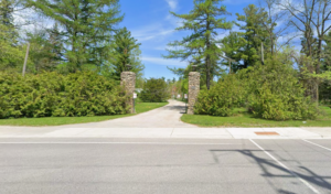
My home is in Angus, Ontario, which lies in the Lake Simcoe-Nottawasaga Treaty 18 lands (Township of Essa 2026). First Nations people have long used the Nottawasaga and Pine River as part of a significant route between Georgian Bay and Lake Simcoe. The Huron-Wendat and Pentu people used the rivers for fish, game birds and furs (Nottawasaga Valley Conservation Authority 2020). They had established agricultural practices and grew corn, beans, and squash in the fertile territories (Fecteau 2004; Williamson 2026). Local archaeological sites exist along the former railway line and document evidence of these early settlements and lifeways that sustained communities for generations before European contact (Archaeological Services Inc 2022).
The settlement in Angus grew in 1830 and expanded with the railway in the 1850s. By 1873, the local newspaper listed seven sawmills and three gristmills in the village. At the time, about 400 people lived in the area (Burnside 2022). Forestry and farming were the primary drivers of the village’s growth.
The land around Angus once supported extensive stands of pine, however, logging removed timber and began the process for clearing farm land as agriculture expanded. The sandy soil became more exposed, and much of the ground was vulnerable (and still is) to wind erosion (Mckague 2024). A 1906 photograph of E.C. Drury on the Angus plains shows stretches of exposed sand that illustrate the extent of deforestation (Simcoe County 2024). The sandy soil that had supported the pine forests was difficult to farm once it was deforested, making agriculture challenging and less productive than farmers had anticipated when they cleared the land for cultivation.
By 1922, Ontario’s Department of Land and Forests had set up a seed-collecting center in Angus and was using Camp Borden to extract seeds (McLaven 2024). The province established the Ontario Tree Seed Plant in 1923 at 141 King Street. Workers dried cones, extracted seeds and sprouted them to check for viability. Each batch was meticulously tracked so the seeds could be matched to areas similar to their genetic adaptation.
Later, as growth continued, it was identified that expansion had put homes and businesses in parts of the floodplains of the Nottawasaga, Pine, and Mad rivers (Sigouin 2001). Essa Township addressed the risk by limiting development in the area. The development and deforestation in the region had already fundamentally changed the landscape and hydrological patterns, so water would reach streams much more quickly rather than being absorbed and trapped in vegetation and released slowly over time. The streams also began to fill more quickly and carried additional sediment and pollutants from urban and industrial runoff, which degraded water quality and ecological conditions downstream throughout the entire watershed system, affecting fish populations and habitat that depended on it (Nottawasaga Valley Conservation Authority 2019).
In 2008, an inventory identified that lake sturgeon were present and would spawn in the Minesing wetlands. Unfortunately, the wetlands also face pressure from invasive Phragmites (Nottawasaga Valley Conservation Authority. n.d.). These tall reeds form dense stands and are compact enough to force out native plants and wildlife habitat. The Nottawasaga Valley Conservation Authority has been monitoring and remediating the species since 2008.
Access to the waterways still remains a treaty issue. It took until 2017 for Canada to formally recognize the existing fishing harvest rights for the local First Nations people by way of the 2018 settlement (Government of Canada 2016). In the same year, the Government of Ontario also closed the King Street seed plant, and the stored seeds were sent to private facilities.
In 2022 there was work on stormwater ponds. These were designed to hold runoff temporarily and release it slowly into the watershed (Community of Angus 2022). The conservation authority’s 2023 watershed assessment indicated that the lake sturgeon still spawned in the Nottawasaga even though there were high levels of nutrient and sediment caused by runoff and agricultural activities. This sediment was identified as mostly coming from the merging of the upstream Innisfil Creek and was significantly impairing overall stream health and ecosystem function in the region despite ongoing conservation efforts and restoration initiatives aimed at improving water quality (Nottawasaga Valley Conservation Authority 2023).
Recently in 2025, the government of Ontario identified the former seed plant land as Surplus and Essa Township drafted a plan that indicates that the site may be helpful to the community and its long-term development goals. Across the street at the Albert Breau Community Park, there is a public canoe and kayak launch that provides access to the Nottawasaga River. This gives the public meaningful access to the Nottawasaga River so that they can appreciate and experience the interface area between urban environments and natural lands that define the region today.
Bibliography
Archaeological Services Inc, and R.J. Burnside and Associates Limited. 2022. Stage 1 Archaeological Assessment – Barrie Collingwood Trail. Archaeological Services Inc. (on behalf of R.J. Burnside and Associates Limited and the County of Simcoe). https://simcoe.ca/wp-content/uploads/2024/02/21EA-145-Stage-1-AA_2022-03-04.pdf.
Burnside, R, and Associates Limited. 2022. Cultural Heritage Report: Existing Conditions Barrie Collingwood Railway Active Transportation Trail Municipal Class Environmental Assessment County of Simcoe, Ontario Draft Report Prepared For. https://simcoe.ca/wp-content/uploads/2024/02/21CH-125-CH-Report-31_DRAFT_-31Jan2022.pdf.
Community of Angus. 2022. Community of Angus Infrastructure Master Plan Schedule “B” Class Environmental Assessment Summary Report FINAL DRAFT Township of Essa. https://www.essatownship.on.ca/media/yi5d5pn1/angus-imp-summary-report-12-sept-2022.pdf.
Fecteau, Rodolphe David. 2004. Preliminary Analysis of Carbonized Macro-Botanical Remains From Petun Sites in Grey and Simcoe Counties, Ontario. Archaeological report. https://ontarioarchaeology.org/wp-content/uploads/oa077-078_part_12.pdf.
Government of Canada. 2016. “Backgrounder: Negotiations With the Williams Treaties First Nations Toward a Negotiated Resolution of the Alderville Litigation.” Rcaanc-Cirnac.Gc.Ca. https://www.rcaanc-cirnac.gc.ca/eng/1490649757949/1539790150833.
Mckague, K. 2024. Soil Erosion -Causes and Effects. https://www.ontario.ca/files/2024-05/omafra-soil-erosion-causes-and-effects-24-019-en-28-05-2024-v1.pdf.
McLaven, Kerry. 2024. “Article: The History of Tree Seed in Ontario | Forests Canada.” Forestscanada.Ca. https://forestscanada.ca/en/article/the-history-of-tree-seed-in-ontario .
Nottawasaga Valley Conservation Authority. 2019. Integrated Watershed Management Plan Nottawasaga Valley Integrated Watershed Management Plan | Ii. https://www.nvca.on.ca/wp-content/uploads/2023/07/Nottawasga_Valley_IWMP_2019-opt.pdf.
Nottawasaga Valley Conservation Authority. 2020. Fort Willow Conservation Area Master Plan. https://www.nvca.on.ca/wp-content/uploads/2023/06/2020-Fort-Willow-Master-Plan.pdf.
Nottawasaga Valley Conservation Authority. 2023. Lower Nottawasaga River Subwatershed Watershed Health Check 2023. https://www.nvca.on.ca/wp-content/uploads/2023/07/Watershed%20Health%20Check_Lower%20Nottawasaga%20River%20Subwatershed-opt.pdf.
Nottawasaga Valley Conservation Authority. n.d. “Invasive Species Phragmites – the Nottawasaga Valley Conservation Authority.” The Nottawasaga Valley Conservation Authority. Accessed November 14, 2026. https://www.nvca.on.ca/invasive-species-phragmites/.
Sigouin, Brenda. 2001. Official Plan of the Township of Essa. https://www.essatownship.on.ca/media/vwflxzxp/official-plan-2001_upd_jan_12_2025.pdf.
Simcoe County. 2024. “Forest History – Simcoe County.” March 25. https://simcoe.ca/explore/forests/about-the-simcoe-county-forest/forest-history/.
Township of Essa. 2026. Welcome Guide for New Residents in Township of Essa. https://www.essatownship.on.ca/media/tu5mcwl4/new-residents-welcome-guide-3.pdf.
Williamson, Ron, and Peter Carruthers. 2023. “The History of Ste. Marie II – the Museum of Ontario Archaeology.” The Museum of Ontario Archaeology, June 8. https://archaeologymuseum.ca/stories/the-history-of-ste-marie-ii/.