Saanich’s Rudd Park
May 15, 2022 By: Jenn Wong
Location: {48.45151267064564,-123.38129529895019}
I live near a large city park and have researched the changing patterns of land-use. Located on Vancouver Island, Saanich is a municipality in Greater Victoria. The area is the traditional territory of the lək̓ʷəŋən peoples represented by the Songhees and Esquimalt Nations, and the W̱SÁNEĆ peoples.[1] In SENĆOŦE, a Salish dialect, Saanich means “emerging” which refers to the sight of Mt Newton “rising” as flood waters receded.[2] Indigenous legends refer to an Arbutus (Arbutus menziesii) tree anchoring their communities during the Great Flood.[3]
The area likely would have been a site of an indigenous managed Garry Oak (Quercus garryana) meadow, with cultivated camas lilies (Camassia quamash). The meadows covered most of the region, and flat landscapes were ideal for harvesting. Until colonial contact, the plant was the main starch food and export for the Lekwungen people and harvested for thousands of years.[4] Land management included weeding, controlled burning, and selective digging and planting. Other pre-contact resources included deer hunting and berry harvesting.
The first European settlement in the area were 3 dairy farms to supply Fort Victoria in 1843.[5] The built environment has evolved since. The lands of South Saanich were “purchased” from the Saanich First Nations via a treaty in 1852, and HBC employees and politicians then bought and cleared vast parcels of land. Treaty ceremonies were interpreted as peace offerings by Salish and Kwakwaka’wakw leaders, as European land ownership was different from indigenous land use and management practices.[6] With a population explosion linked to the Fraser River gold rush, and the Pre-Emption Act, brought British settlers to the area. First Nations people were pushed off their traditional territory onto reserves. Forests and Garry Oak meadows were cleared for European crops, and farmers let their livestock root for camas bulbs.[7] In 1880, the area is drawn as a large quadrilateral farm plot that abuts the Colquiz River. [8]
In 1906, the district municipality of Saanich was incorporated, and a hydroelectric plant was built to service the area.[9] In general, this area saw rapid residential growth between 1910 and 1914 as a suburb of the growing city of Victoria were connected via an electric railway. In 1913, roads were starting to be paved and hydro lines were installed 3 years later.[10]
In 1906, a single mother of 8 children, Martha Rudd purchased a plot of land and herd of cattle. She built a large home, orchard and produce fields.[11] On the farm, she erected Victoria’s first grain silo. After her death, the land was divided. One son had a dairy farm until 1965, and the other was a city councilor. In the 1940’s, five acres were donated to the District of Saanich for a park. The surrounding area was subdivided for mixed residential and commercial use by the 1950’s.[12]
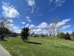
Today, the park has a playground, a basketball court and a large grass field dotted with English Daisies (Bellis perennis L.) and the occasional dandelion. Wildlife in the area includes skunks, ravens, songbirds, grey squirrels and pet dogs. The park is lined with horse chestnuts, pines, and ornamental cherries. A great London Plane (Platanus × acerifolia) tree with a four-and-a-half-foot wide trunk stands two stories tall at the corner on the park. A non-native species, this hybrid European tree is likely over 100 years old, and was represents colonization as urban street trees and lawns have replaced native ecosystems.
[1] “Indigenous Relations,” District of Saanich, accessed April 7, 2022, https://www.saanich.ca/EN/main/community/Indigenous-Relations.html.
[2] Saanich Archives, “Saanich Place Names,” (May 29, 2020): 91.
[3] Nancy J. Turner, Ancient Pathways, Ancestral Knowledge : Ethnobotany and Ecological Wisdom of Indigenous Peoples of Northwestern North America (Montreal: McGill-Queen’s University Press, 2014), 269.
[4] Briony Penn, “Restoring Camas and Culture to Lekwungen and Victoria: An interview with Lekwungen Cheryl Bryce,” Focus Magazine, June 2006.
[5] District of Saanich, “Saanich Heritage Register 2008,” 8.
[6] Nancy J. Turner, Ancient Pathways, Ancestral Knowledge : Ethnobotany and Ecological Wisdom of Indigenous Peoples of Northwestern North America (Montreal: McGill-Queen’s University Press, 2014), 222.
[7] “Garry oaks, camas reveal agricultural impacts of colonialism on Vancouver Island,” Saanich News, Sep. 25, 2021, https://www.saanichnews.com/community/garry-oaks-camas-reveal-agricultural-impacts-of-colonialism-on-vancouver-island.
[8] The Barry Lawrence Ruderman Map Collection, “Map of the South-eastern Districts of Vancouver Island, B.C. 1880,” accessed May 1, 2022, https://exhibits.stanford.edu/ruderman/catalog/hj266vk0850.
[9] Saanich Archives, “Saanich Place Names,” accessed May 1, 2022, https://www.saanich.ca/assets/Parks~Recreation~and~Community~Services/Documents/Archives~Collections~and~Research/Category~8/Saanich%20Place%20Names.pdf.
[10] District of Saanich, “Uptown-Douglas Plan,” 143, 2020, https://www.saanich.ca/assets/Community/Documents/Planning/Action~Plans/Uptown-Douglas-Plan-July2020-web-section10.pdf.
[11] Saanich Archives, “How did Rudd Park get its Name?,” https://www.saanich.ca/assets/Parks~Recreation~and~Community~Services/Documents/Archives~Collections~and~Research/Category~10/Rudd%20Park%20name.pdf.
[12] Atlas Map of Victoria B.C., Pocket Edition, 33 (1948).
https://www.saanich.ca/assets/Parks~Recreation~and~Community~Services/Documents/Archives~Collections~and~Research/Category~4/Atlas_map_1948.pdf.